Spatial Data
Advertisement
LiegKat-Archiv v.0.9.4
Liegkat-Archiv delivers ALK converters for spatial data formats (EDBS, BGRUND, SQD, DFK, HK) and coordinate systems used in German cadastral agencies before ALKIS into KML and JML.
Advertisement
RSGISLib v.b.1.6.4
The remote sensing and GIS library is a set of C++ libraries and commands for the processing of spatial data (raster, vector and point cloud).
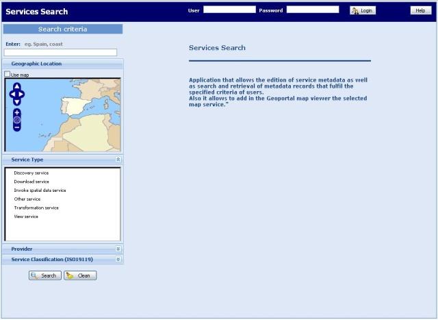
SpatiumCube v.1.0.13
SpatiumCube is open source technology for the easily development of Spatial Data Infrastructures (SDIs) and services over them.
DbForge Data Generator for MySQL v.2.5
dbForge Data Generator for MySQL is a powerful GUI tool for creating massive volumes of realistic test data for MySQL databases
Geoida v.1.0
Geoida is a software product that will benefit members of the surveying and related professions for the day-to-day routine processing, coordination and adjustment of spatial survey data, from routine pick-up surveys to complex networks of geodetic sc
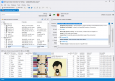
Geosoft Desktop Cataloger v.7.5.1
The Geosoft Desktop Cataloger is a free utility that helps you build a catalog of your spatial files from your local drives, and lets you easily find that data when using Geosoft exploration software (Oasis montaj, Target) or Geosoft exploration soft
SkyJUMP v.1.2.2
Edit and generate spatial datasets with the help of this tool. SkyJUMP is an open source GIS software for the creation and use of facility maps and data on small to medium sized areas such as cities or military bases.
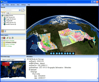
Dapple v.2.1.4
Dapple is a global data explorer designed to provide an open and optimal environment for visualizing, presenting and sharing massive quantities of geoscientific data on desktop computers.
Canvas GIS Advanced (Mac) v.9.0.4
About Canvas GIS Advanced (Mac)Adds native support for Geographic Information System (GIS) data to Canvas.
ObjectLand v.2. 7. 2006
GIS ObjectLand processes data organized as geoinformation database (GDB). Basic GDB components are maps, themes, tables, queries, external databases, layouts, users, and styles.
ERDAS ER Mapper v.7 2
ERDAS ER Mapper allows you to visualize, enhance and combine images for a broad array of applications. Extracting the quantitative information you need, ERDAS ER Mapper makes your data more meaningful to solve business problems.